File:Central Asia - political map - 2000.svg
Jump to navigation
Jump to search

Size of this PNG preview of this SVG file: 755 × 599 pixels. Other resolutions: 302 × 240 pixels | 605 × 480 pixels | 967 × 768 pixels | 1,280 × 1,016 pixels | 2,560 × 2,033 pixels | 995 × 790 pixels.
Original file (SVG file, nominally 995 × 790 pixels, file size: 174 KB)
This is a file from the Wikimedia Commons. Information from its description page there is shown below.
Commons is a freely licensed media file repository. You can help. |
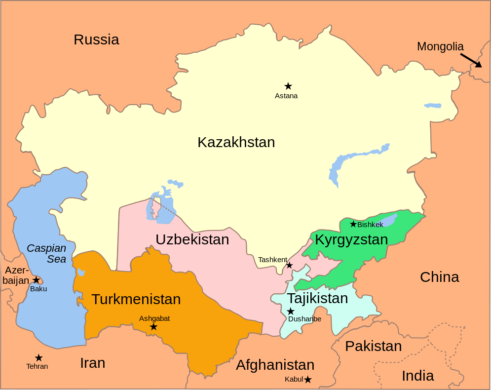
| Description | Political Map of the Caucasus and Central Asia, circa 2000 |
| Date | (UTC) |
| Source | |
| Author |
|
| Other versions |
[]
|


This file is licensed under the Creative Commons Attribution-Share Alike 3.0 Unported license.
- You are free:
- to share – to copy, distribute and transmit the work
- to remix – to adapt the work
- Under the following conditions:
- attribution – You must give appropriate credit, provide a link to the license, and indicate if changes were made. You may do so in any reasonable manner, but not in any way that suggests the licensor endorses you or your use.
- share alike – If you remix, transform, or build upon the material, you must distribute your contributions under the same or compatible license as the original.

|
This SVG file contains embedded text that can be translated into your language, using any capable SVG editor, text editor or the SVG Translate tool. For more information see: About translating SVG files. |
Original upload log
This image is a derivative work of the following images:
- Image:Caucasus_central_asia_political_map_2000.jpg licensed with PD-USGov
- 2004-11-09T01:20:18Z Annalog 1390x1036 (167714 Bytes) The Caucasus and Central Asia Political Map 2000
Uploaded with derivativeFX
File history
Click on a date/time to view the file as it appeared at that time.
| Date/Time | Thumbnail | Dimensions | User | Comment | |
|---|---|---|---|---|---|
| current | 15:20, 9 April 2024 | | 995 × 790 (174 KB) | Whhalbert | File uploaded using svgtranslate tool (https://svgtranslate.toolforge.org/). Added translation for zh-hk. |
| 19:42, 9 November 2008 |  | 995 × 790 (160 KB) | Themightyquill | {{Information |Description=Political Map of the Caucasus and Central Asia |Source=*Image:Caucasus_central_asia_political_map_2000.jpg |Date=2008-11-09 19:41 (UTC) |Author=*derivative work: ~~~ *[[:Image:Caucasus_central_asia_political_map_2000.jpg|] |
File usage
The following page uses this file:
Global file usage
The following other wikis use this file:
- Usage on hy.wikipedia.org
- Usage on incubator.wikimedia.org
- Usage on kn.wikipedia.org
- Usage on ko.wikipedia.org
- Usage on pl.wikivoyage.org
- Usage on ru.wikivoyage.org
- Usage on sc.wikipedia.org
- Usage on sr.wikipedia.org
- Usage on ug.wikipedia.org
- Usage on www.wikidata.org