File:Map sagegrouse range2000.JPG
Jump to navigation
Jump to search
No higher resolution available.
Map_sagegrouse_range2000.JPG (720 × 540 pixels, file size: 62 KB, MIME type: image/jpeg)
This is a file from the Wikimedia Commons. Information from its description page there is shown below.
Commons is a freely licensed media file repository. You can help. |
Summary
| Description |
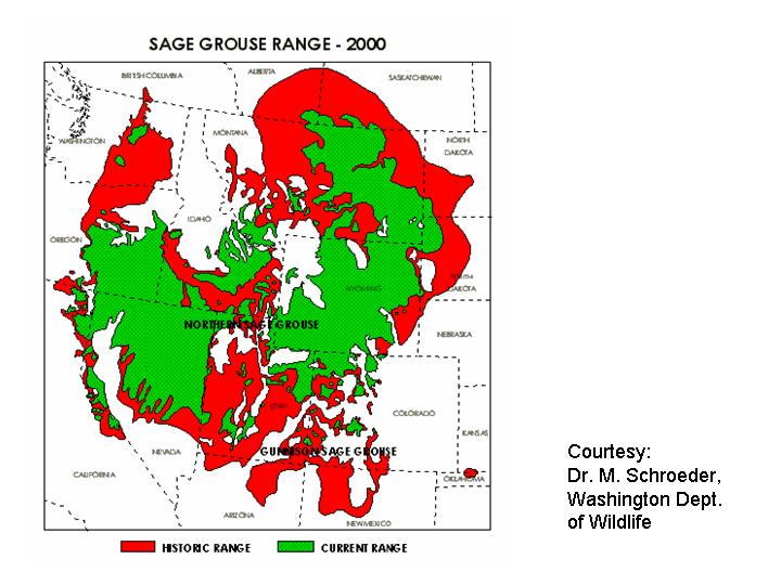
English: Range map of the Greater Sage Grouse (Centrocercus urophasianus) — historical (red) and present day (green) in western North America.
|
| Source | http://www.fws.gov/mountain-prairie/species/birds/sagegrouse/map_sagegrouse_range2000.JPG |
| Author | M. Schroeder |
Licensing
This image or recording is the work of a U.S. Fish and Wildlife Service employee, taken or made as part of that person's official duties. As a work of the U.S. federal government, the image is in the public domain. For more information, see the Fish and Wildlife Service copyright policy.
|
 |
File history
Click on a date/time to view the file as it appeared at that time.
| Date/Time | Thumbnail | Dimensions | User | Comment | |
|---|---|---|---|---|---|
| current | 13:26, 10 January 2009 | | 720 × 540 (62 KB) | Whhalbert | {{Information |Description={{en|1=Range of Greater Sage Grouse (Centrocercus urophasianus), historical and present (2000). The U.S. Fish and Wildlife Service}} |Source=http://www.fws.gov/mountain-prairie/species/birds/sagegrouse/map_sagegrouse_range2000.J |
File usage
The following page uses this file:
Global file usage
The following other wikis use this file:
- Usage on ceb.wikipedia.org
- Usage on de.wikipedia.org
- Usage on ru.wikipedia.org
- Usage on sv.wikipedia.org
- Usage on vi.wikipedia.org
- Usage on zh.wikipedia.org