File:South East England districts 2011 map.svg
Jump to navigation
Jump to search

Size of this PNG preview of this SVG file: 749 × 600 pixels. Other resolutions: 300 × 240 pixels | 600 × 480 pixels | 959 × 768 pixels | 1,279 × 1,024 pixels | 2,558 × 2,048 pixels | 1,425 × 1,141 pixels.
Original file (SVG file, nominally 1,425 × 1,141 pixels, file size: 2.18 MB)
This is a file from the Wikimedia Commons. Information from its description page there is shown below.
Commons is a freely licensed media file repository. You can help. |
Summary
| Description |
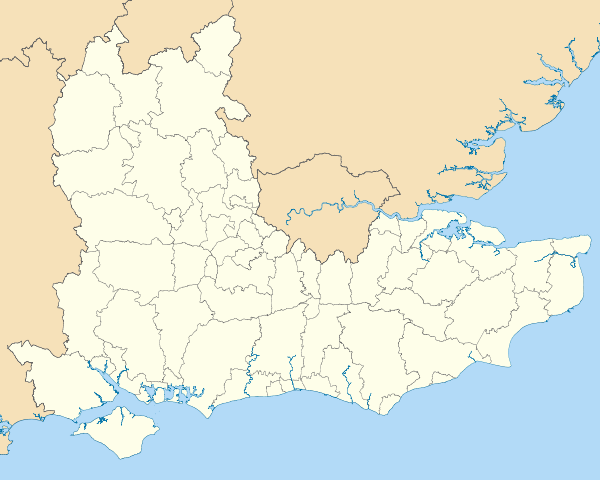
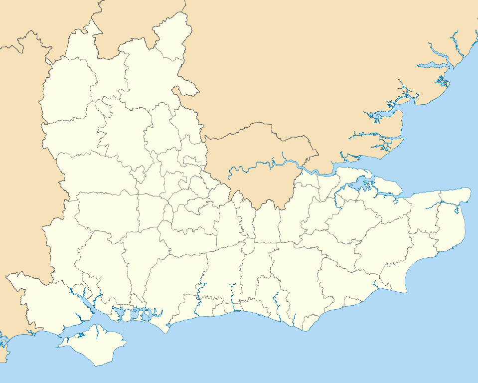
Map of the South East England region showing the administrative districts. Equirectangular map projection on WGS 84 datum, with N/S stretched 160% Geographic limits:
|
| Date | |
| Source |
|
| Author | Nilfanion, created using Ordnance Survey data |
| Other versions |
Derivative works of this file: |
Licensing
I, the copyright holder of this work, hereby publish it under the following licenses:
This file is licensed under the Creative Commons Attribution-Share Alike 3.0 Unported license.
- You are free:
- to share – to copy, distribute and transmit the work
- to remix – to adapt the work
- Under the following conditions:
- attribution – You must give appropriate credit, provide a link to the license, and indicate if changes were made. You may do so in any reasonable manner, but not in any way that suggests the licensor endorses you or your use.
- share alike – If you remix, transform, or build upon the material, you must distribute your contributions under the same or compatible license as the original.

|
Permission is granted to copy, distribute and/or modify this document under the terms of the GNU Free Documentation License, Version 1.2 or any later version published by the Free Software Foundation; with no Invariant Sections, no Front-Cover Texts, and no Back-Cover Texts. A copy of the license is included in the section entitled GNU Free Documentation License. |
You may select the license of your choice.
File history
Click on a date/time to view the file as it appeared at that time.
| Date/Time | Thumbnail | Dimensions | User | Comment | |
|---|---|---|---|---|---|
| current | 19:04, 1 May 2011 | | 1,425 × 1,141 (2.18 MB) | Nilfanion | == Summary == {{Information |Description=Map of the South East England region showing the administrative districts. Equirectangular map projection on WGS 84 datum, with N/S stretched 160% Geographic limits: *West: 2.0W *East: 1. |
File usage
There are no pages that use this file.
Global file usage
The following other wikis use this file:
- Usage on ar.wikipedia.org
- Usage on bs.wikipedia.org
- Usage on ceb.wikipedia.org
- Usage on en.wikipedia.org
- Hastings
- Isle of Wight
- Oxford
- Portsmouth
- Reading, Berkshire
- South East England
- Oxfordshire
- East Sussex
- Brighton and Hove
- Bracknell Forest
- Borough of Runnymede
- Crawley
- Reigate and Banstead
- Mid Sussex District
- Medway
- Hart District
- West Berkshire
- Borough of Waverley
- Royal Borough of Windsor and Maidenhead
- Adur District
- Arun District
- Gosport
- Sevenoaks
- Borough of Dartford
- Basingstoke and Deane
- Worthing
- City of Milton Keynes
- Cherwell (district)
- Wealden District
- Vale of White Horse
- Tonbridge and Malling
- East Hampshire
- Rushmoor
- Test Valley
- Gravesham
- Borough of Swale
- Folkestone and Hythe District
- South Oxfordshire
- West Oxfordshire
- Borough of Spelthorne
- Surrey Heath
- Borough of Elmbridge
- Mole Valley
- Epsom and Ewell
- Tandridge District
- Rother District
- Lewes District
View more global usage of this file.