File:Txu-pclmaps-oclc-22834566 g-7a.jpg
Jump to navigation
Jump to search

Size of this preview: 800 × 574 pixels. Other resolutions: 320 × 230 pixels | 640 × 459 pixels | 1,024 × 735 pixels | 1,280 × 918 pixels | 2,560 × 1,836 pixels | 9,354 × 6,710 pixels.
Original file (9,354 × 6,710 pixels, file size: 26.09 MB, MIME type: image/jpeg)
This is a file from the Wikimedia Commons. Information from its description page there is shown below.
Commons is a freely licensed media file repository. You can help. |
Summary
| Description |
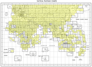
English: Tactical Pilotage Chart Series - World 1:500,000 Scale TPC G-7A Afghanistan, China, Pakistan, U.S.S.R. |
|||||||||
| Date |
Compiled: March 1974 Air Information Current Through: 29 November 1984 Revised: December 1984 Reprinted by NIMA: 11-97 Map Collection: Sep 99 Scanned: 2011-10-05 06:35:17 |
|||||||||
| Source | Original LinkArchived Link | |||||||||
| Creator | ||||||||||
| Geotemporal data | ||||||||||
| Bounding box |
|
|||||||||
| Georeferencing | ||||||||||
-
 Index Map

Licensing
This work is in the public domain in the United States because it is a work prepared by an officer or employee of the United States Government as part of that person’s official duties under the terms of Title 17, Chapter 1, Section 105 of the US Code.
Note: This only applies to original works of the Federal Government and not to the work of any individual U.S. state, territory, commonwealth, county, municipality, or any other subdivision. This template also does not apply to postage stamp designs published by the United States Postal Service since 1978. (See § 313.6(C)(1) of Compendium of U.S. Copyright Office Practices). It also does not apply to certain US coins; see The US Mint Terms of Use.
|
 | |
| This file has been identified as being free of known restrictions under copyright law, including all related and neighboring rights. | ||
File history
Click on a date/time to view the file as it appeared at that time.
| Date/Time | Thumbnail | Dimensions | User | Comment | |
|---|---|---|---|---|---|
| current | 11:27, 27 December 2019 | | 9,354 × 6,710 (26.09 MB) | Geographyinitiative | User created page with UploadWizard |
File usage
The following 18 pages use this file:
Global file usage
The following other wikis use this file:
- Usage on az.wikipedia.org
- Usage on en.wikipedia.org
- Yarkant County
- Artush
- Kashgar Prefecture
- Poskam County, Xinjiang
- Maralbexi County
- Payzawat County
- Kargilik County
- Yopurga County
- Makit County
- Yengisar County
- Akto County
- Qira County
- Lop County
- Shule County
- Hotan Prefecture
- Kokyar
- Pishan hostage crisis
- Mazartag
- Seriqbuya
- Afghanistan–China border
- China–Tajikistan border
- Baykurut
- Koxtag
- Muji Town, Hotan
- Kezi River
- Usage on es.wikipedia.org
- Usage on ja.wikipedia.org
- Usage on ro.wikipedia.org
- Usage on uz.wikipedia.org
- Usage on zh.wikipedia.org